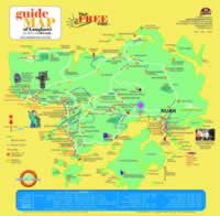
 Location of Langkawi Island
Kuala Lumpur | Selangor | Johor | Kedah | Kelantan | Pahang | Perak | Terengganu | Negeri Sembilan | Perlis | Melaka | Pulau Pinang | Putrajaya | Sabah | Sarawak | Labuan
| Main > Langkawi Map | |||
| It is a print version copy of Langkawi's Free Map for your reference while travelling in Langkawi. This copy is distributed freely with about 300,000 copies in a year. It has been in circulation since 1995 and is given free when your arrive at the main enterence such as airport and jetties, and also at selected hotels. In this section, we suggest you get the map in advance by print it out. | |||
|
|||
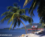
About Kuah travel information Other map link The island is one of three inhabited ones in an archipelago of 104. Langkawi is the biggest island and tourism is its primary source of revenue. You may interest Old painting of beautiful witches |
|||

